
GIS and its potential for UCD
By Assoc Professor Gerald Mills, Head of School, School of Geography.
A great deal of information that UCD gathers contains valuable geographic information that is rarely used for planning purposes. Geographic Information Systems (GIS) describe software that is capable of analysing the spatial patterns present in data alongside traditional statistical analysis.
A good example of how GIS could be used is in the examination of the school origins of students at UCD.
The great majority of students that come to Belfield for the first time in September 2017 will be drawn from the Irish school system and most will have completed their leaving certificate (LC) in one of over 700 secondary schools that are managed by the Dept. of Education and Skills. The DoES maintains a database of these schools which identifies each with a unique roll number and has information on the total number of students, the full address, etc. There are a few other schools (e.g. the Institute of Education in Dublin) that are not included in this database. Address-matching software can be used to convert these data into a location (a x,y co-ordinate) and GIS can map these. The information gathered by UCD when students apply for a programme also includes the name of the school where they completed their LC, so these can be matched with the DoES database.
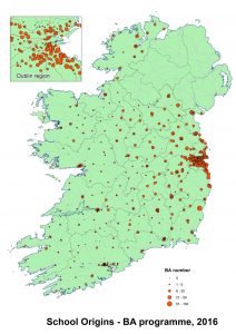
The map to the right shows the number of applicants for the BA programme in 2016 (5453). The distinct pattern that emerges can be explained by a number of factors including physical proximity, school size, transport options, socio-economic opportunities and historic links to certain institutions; of course all of these factors are correlated. For example, more than one-fifth of BA applications come from schools within 5km of Belfield and distant schools are usually along the coast where there are public transport routes (see Table). In the same vein, there were no applications from Tallaght Community School, which has 750 students and is only 8km away.
It is a simple matter in GIS to combine these data with other information (census information, transport routes, etc.) to think strategically about increasing the geographical (and socio-economic) reach of UCD. Moreover, such analysis could provide a basis for developing substantive links with schools based on existing strengths and opportunities. Other UCD could be combined to ask specific questions, for example: where are UCD alumni teachers? and which schools produce Law students?
Here I have focused on student applications, which reveals the extraordinary reliance of the largest university programme in the country on relatively few schools. However, the potential for a geographic approach to the management and analysis of university information (e.g. transport planning and alumni relations) is considerable.
| The top ten schools by percentage of students applying to UCD | |||||
| School Name and Address | Tot | BA15 | BA16 | %UCD | Dist |
| Gonzaga College Sandford Road Ranelagh Dublin 6 | 547 | 58 | 46 | 8.41 | 2 |
| Loreto College Foxrock Foxrock Dublin 18 | 642 | 44 | 55 | 8.57 | 5 |
| Blackrock College Rock Road Blackrock Co. Dublin | 999 | 71 | 91 | 9.11 | 2 |
| Holy Child Secondary School Military Road Killiney Co. Dublin | 360 | 35 | 33 | 9.17 | 9 |
| Coláiste Eoin Baile an Bhóthair Bóthair Stigh Lorgan Co Dublin | 491 | 44 | 47 | 9.57 | 1 |
| St Marys College Rathmines Dublin 6 | 430 | 21 | 42 | 9.77 | 4 |
| St Joseph Of Cluny Secondary School, Killiney Co Dublin | 402 | 18 | 40 | 9.95 | 8 |
| St Michaels College Ailesbury Road Dublin 4 | 594 | 43 | 60 | 10.10 | 2 |
| Coláiste Chú Chulainn Dundalk Dundalk Louth | 210 | 15 | 22 | 10.48 | 79 |
| St Conleths College 28 Clyde Road, Dublin 4 | 244 | 18 | 32 | 13.11 | 3 |
| Column information: Tot number of students in that school in all years; BA15/BA16 number of BA applicants by year; %UCD percent of all students in School, applying to UCD and; D_UCD distance (km) to Belfield from school. Note that the private schools like the Institute of Education are not included as the student population is not known | |||||
| Author: Gerald Mills, Associate Professor | Head of School | Urban Climatology
I am a physical geographer with particular interests in climate and in geographic information systems (GIS). My research interests are in the climates of cities and the use of observations and models to mitigate (and adapt to) urban climate effects and regional/global climate changes. I use GIS to support both my research and teaching. The work presented here developed from an analysis of where stage-one geography students came from, which we linked to schools and teachers as part of a plan to develop an network to engage with the broader geography education community. |